
Questions?
Email us at: JandK@LivingGoldPress.com
 HOME
HOME

| |
Email us at: JandK@LivingGoldPress.com
|
|
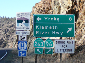
State of Jefferson Byway
|
|
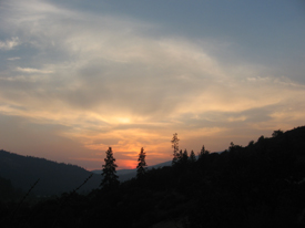
The State of Jefferson Byway traverses a rural relatively remote part of far northern California, a delightful drive through natural and historic landscapes. |

|
In 1941 they were all riled up about roads. In fact, the good citizens were so riled up about the sorry condition of the area’s roads that they decided to form their very own state to remedy the situation. State government is ignoring us, the thinking was, so we’ll secede, form the 49th state and take care of ourselves.
This was the idea behind the State of Jefferson.
Some decades later, we know that it was Alaska that became the 49th state and that these few discontented counties of California and Oregon clearly still belong to their respective states. But the “spirit” of the State of Jefferson has lived on. Rural and mountainous, physically and culturally far removed from populated areas, this area is not what comes to mind when you think “California” (or even “Oregon”). It’s not quite the “last frontier” (that’s Alaska too, folks). But to this day people in the region do tend to view themselves as rugged individualists.
Perhaps this is why the State of Jefferson movement, that brief time of fame and fired-up passions so long ago, has been reclaimed, especially on the California side of the border. The two XXs of the “double crossed” symbol displayed here and there throughout the area attest to a (somewhat unfocused) discontent with “the way things are” but more importantly, they demonstrate a pride in the colorful episode of history.
The State of Jefferson Scenic Byway cuts through the heart of this onetime “state.” |
|
“Bring Your Own Gravel” As the rebellion unfolded the story was well documented in a series of Pulitzer Prize-winning reports in the San Francisco Chronicle. It appears that the movement was at least partly tongue-in-cheek, as in “a publicity stunt”. But if you had been stopped by rifle-toting secessionists at the Highway 99 roadblock and handed the State of Jefferson Proclamation of Independence, you might not take it so lightly. (Can you imagine that happening today? Here comes the SWAT team!)
As it happened, the 1941 episode is only the best-known secession movement; there had been several others. In 1852, a State of Shasta was petitioned for. In 1853, it was the State of Klamath, and in 1854 a State of Jackson. Back then states were still actively being brought into the Union, so perhaps the plans weren’t as far-fetched as they might seem today.
But by 1941 we had 48 states and the boundary lines weren’t moving. Still, many residents of southern Oregon and northwestern California were unhappy. Most of the local populace stemmed from either the rough-and-tumble Gold Rush days or from the Great Depression, when families moved in and tried to scratch out a living by doing a little mining, hunting game (legally or not) and growing a big garden.
So in 1941 the residents had what we might call an exploitive predisposition, i.e. they wanted to take what the land had to offer. They were frustrated at the difficulty, due to lack of good roads, of getting to and sending out some of the abundant resources of the area, most of it on public land, such as copper, chrome and lumber.
This time around, the call was for a State of Jefferson. The mantra went, “If our roads you will travel, bring your own gravel.” There were to be other benefits, among them no sales, income or liquor taxes. No wonder this was a popular idea! |
|
Why Jefferson? By the fall of 1941 the separate state idea was gaining momentum. Representatives from the interested Oregon and California counties held meetings, a Governor was elected, Yreka, California was designated the State Capital. The name for the proposed state was chosen in a newspaper contest (prize: $2). Thomas Jefferson, our third president, was picked because he had authored the Declaration of Independence and for his stance against a strong Federal government. Also cited were his mega real estate deal, the 1803 Louisiana Purchase and the 1804-6 Lewis and Clark Expedition, both of which helped give us “the West.”
Time and Life sent out photographers. The “Governor” was sworn in on December 4th in front of the Yreka courthouse with tame, but leashed brother bears Itchy and Scratchy at his side. Alas, three days later Pearl Harbor was bombed. With the nation in shock, the State of Jefferson movement suddenly seemed trivial and so it was dropped.
However, the State of Jefferson lives on as a State of Mind, and in the names of assorted area businesses and the local NPR station, Jefferson Public Radio. And, of course, in the name of one of the 151 National Scenic Byways recognized by the US Department of Transportation.
|
|
Jefferson, the Road The State of Jefferson Scenic Byway is 108 miles long. It begins at the north edge of the “state capital” of Yreka. This town of 7,300, biggest one in a county with more cattle than people, was founded in 1851 by gold miners. When the Mother Lode a few hundred miles south got overcrowded, prospectors spread north seeking new gold fields. Well, they found them, and Yreka, first called Thompson’s Dry Digging’s, became the area’s mining supply center. An impressive exhibit of local gold is on display at the county courthouse.[Note from 2020: the gold was stolen a few years ago and remains mostly unrecovered.] The town has a Historic District along Miner St. and the surrounding neighborhoods of Victorian and Craftsman style homes.
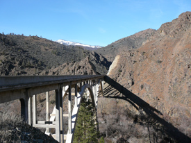
Leaving town heading north, the Byway soon winds through rocky terrain high above the Shasta River. This stretch of Byway is an 8-mile section of historic US99. The original 1914 dirt (never paved) highway can be seen way down below alongside the river.
The main features through here are the deep shear road cuts, rock retaining walls and five historic circa 1930 bridges. Taking a moment to contemplate the “cuts and fills,” it’s clear that building this “new” (1931) US99 had to be quite an undertaking. “240 Tons of Explosives Were Used Excavating Gorge Highway” bragged the headline of a 1932 article in California Highways and Public Works. Two of the bridges are stunning concrete arches, and a third is a 414 foot long cantilevered steel span rising 270 feet above river level. [The historic bridge that crossed the Klamath was replaced with a new but attractive concrete arch in 2020.]
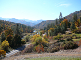
After crossing the much larger Klamath River just above its confluence with the Shasta, old 99 continues its run north to Oregon while the Byway makes a sharp turn onto two-laned California State Highway 96, the Klamath River Highway. The Byway just passed through a striking moonscape but now heads west and ever closer to the moist air of the Pacific Ocean. The landscape grows progressively more verdant. The highway generally follows the curves of the river all of the 62 miles to Happy Camp, providing plenty of opportunities to pull over and check out the waters.
The State Highway, such as it was, was built in the mid-1920s, an improvement over the rough wagon road but still an unpaved muddy mess in the winter. Keep your eyes peeled for cement “C Blocks”, similar to mileposts, that were planted along all state highways in that era. There are also a few vintage bridges although most were either replaced in later years to accommodate heavy log trucks or washed away in the 1964 “hundred year” flood.
|
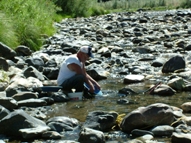 |
Gold! You will notice signs of mining activities in your travels, most notably large conical piles of many-colored river rock called tailings. Gold Fever mandated heavy labor; sometimes the river itself was actually moved aside to get at the gold. To do this wooden wing dams were built out into the water creating a fenced-in enclosure. This structure diverted the main flow over to the side, then the remaining water was pumped out leaving part of the rocky riverbed dry. Next, swinging derricks were used to move the rocks and boulders one by one, stacking them into the tailing piles we see today. The sand and gravel beneath the rocks containing the gold could then be scooped out for further processing. This was only one method of getting out the riches. In a later era (1930s) huge building-sized dredges dug slow swaths through certain parts of the river, leaving neat rows of rock tailings in evidence of their paths.
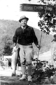
During the height of the 19th century mining era this river corridor was teeming with thousands of people. Just about every (river) bar had a settlement, and you can bet that every settlement had at least one bar! Today the population is sparse. This Scenic Byway is mainly a nature trip with only very small towns and adequate but few facilities. You just might see more ducks and deer than people, at least until you arrive in Happy Camp.
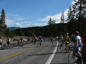
The road is generally uncrowded and–note to secessionists: smoothly paved! Perhaps this is why motorcyclists and bicyclists have taken to the road in recent years. From the late 1960s through about 1990 sharing the road with logging trucks could be problematic, but the decline of the timber industry had made for a more enjoyable road trip for the rest of us.
|
|
What’s to See? Soaring eagles, bounding deer, frothy waters, scenic views, abundant greenery, tidbits of historic artifacts and a stop at a country store should keep all but the most jaded urbanite entertained. I will list just a few other things to watch for, from east to west.
Tree of Heaven Campground. The campground is a grassy, shady oasis located on a sharp bend of the river. In the Gold Rush days Chinese raised veggies on the flat river bar to sell to miners, leaving behind the Trees of Heaven from their native land. One thing that makes the campground special is its handicapped accessibility. Besides accessible campsites, there is a paved interpretive birding trail and paved access to the “put in” for boats and river rafts. This connects (by water) to the accessible raft “take out” at Gottville seven miles down. River rafting and kayaking is big business on the Klamath in the summer months.
River Accesses. All the way down the river you will notice official River Accesses. These are great places to pull over for a picnic or a look-see.
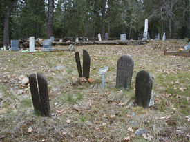
Cemeteries. Browsing through one of the many old cemeteries gives you a feel for local history. They include Kanaka, Hamburg, Scott Bar and Ft. Goff.
Klamath River. (The town, not the river.) Quigley’s Store has been in business since the 1920s. The Quigley in question (no live Quigleys around anymore) was nicknamed “Moon” because of the moonshine still he operated in the gulch just down the road. His ghost is said to visit the store on occasion. During Prohibition this was a popular area for the well-heeled to come for extended fishing (and imbibing) trips. A few lodge-type dwellings from that time period remain. Then owners of what is locally called the Hoover House (a private residence) hosted Herbert Hoover, an avid fly fisherman, before his presidency. The Crocker family of Transcontinental Railroad fame built a large spread that remained in the family until recent years. A Standard Oil Company executive built another. There were also a number of commercial lodges all along the river.
Other towns. Scott Bar: Take a 3 mile detour off the Byway to the little community of Scott Bar and you will feel like you’ve traveled back in time. The post office, surely one of the smallest in existence, also houses a branch of the county library. Mining equipment is on display next to the road and the Quartz Hill mine seen across the river was one of the richest in the county. Hamburg: It’s hard to believe that this little burg had a population of 10,000 during the height of mining. A homesick German miner named it. Seiad Valley: Here the river corridor opens up into a wide pretty valley overlooked by a grouping of the three Devils Peaks. This is also a stopping point for hikers on the Pacific Crest Trail, a place where they can pick up mail and supplies as they walk from Mexico to Canada! Ft. Goff: Site of a forested riverside campground and cemetery, and of a very long ago short-lived military encampment.
Other roads. Secessionists would be pleased to know that hundreds of miles of unimproved roads have since built on the surrounding National Forest land. They can be accessed off the Scenic Byway, to the delight of backroad enthusiasts (but best to grab a National Forest map).
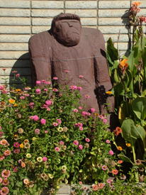
Happy Camp. The small town has become almost-famous for the tall metal Bigfoot statue at the town entrance. It stands in front of what was a gas station and now is an art gallery. The town, surprisingly, has a very active community of artists. It also has a visitor’s and interpretive center at the Forest Service office, the lovely River Park, a market, a liquor store, a motel, and gas. Stock up and fill up for this is the last bit of civilization on the State of Jefferson Scenic Byway!
|
 |
Onward, Upward, Over and Down The final 38 miles of the State of Jefferson Scenic Byway leads away from the river, into the woods and up and over a mountain. Locally referred to as “going over Grayback”, our route turns north under Bigfoot’s nose and the climb begins. Don’t try it in the winter though, or you won’t make it to the end without snowshoes, for Grayback Mountains is usually snowbound November to May, and the road doesn’t get plowed.
It’s a steep and windy but very beautiful drive. You cross into Oregon without even knowing it. The Byway ends at a junction with US199, but the fun doesn’t stop. A left turn will lead to the California redwoods, a right turn is the way to go for Oregon Caves National Monument. Either way, you will still be within the realm of the Mythical State of Jefferson.
|