
Questions?
Email us at: JandK@LivingGoldPress.com
 HOME
HOME

| |
Email us at: JandK@LivingGoldPress.com
|
|
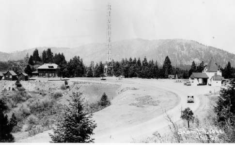
Highpoint of Highway 99, |
Another view. |
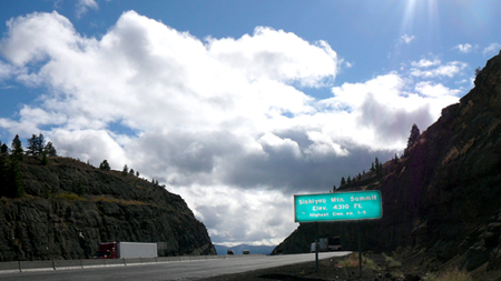
| Siskiyou Pass currently tops out at 4310'. | |
A Richfield Beacon station stood right at the top but it's glory lasted only a few years. MORE about this chain of gas stations. |
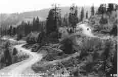 |
| It was a long and winding road down the north side of the mountains into Oregon. GO TO a larger photo |
 |
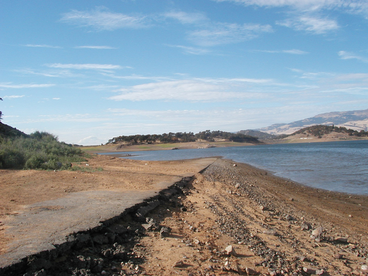
| At the bottom of the grade the old road now drops into Emigrant Lake which covers the townsite of Klamath Junction. GO TO a larger photo. |
|
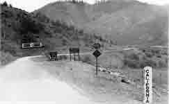
| The pavement ended at the Oregon/California state line on the south slope of the Siskiyou Mountains. GO TO a larger photo |
|
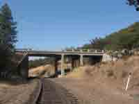
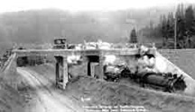
| Steinman overcrossing was built on the pre-US99 Pacific Highway in 1914 and is still in use. See an earlier view below. GO TO a larger photo |
|
| GO TO a larger photo |
|
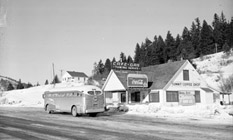
| The Summit Coffee Shop was in business for about 25 years, until I-5 opened in 1966. GO TO a larger photo |
Part Three |
Sam Hill in an OvercoatWhen the Good Roads Movement swept the country in the first and second decades of the 20th century and “named highways” (numbers were not doled out until 1926) appeared here and there, the Pacific Northwest had Sam Hill as its premier road advocate. This large, eccentric and energetic character, although in employ as an attorney for the Great Northern Railroad, considered good roads his “religion”. After a mere 34 mile road trip that left him “sore inside and out” he vowed to build a hard-surfaced highway from the California/Mexico border all the way to Vancouver BC, a distance of over 1600 miles. Sam and his friend A.E. Todd formed the Pacific Highway Association. Hill tirelessly promoted the Pacific Highway by giving lectures illustrated with hand-tinted “lantern slides”, testified before Congress, traveled to Europe to study road building methods, and built experimental roads on his property in Washington. Sam Hill’s reward came on a cold late November day in 1913 when, clad in heavy wool coat and hat, he stood amongst a crowd of dignitaries and spectators at the foot of the Siskiyous on the Oregon side. Brandishing a ceremonial shovel for the press, he turned over the first shovelful of earth on the Pacific Highway. Jackson County, Oregon had led the state in pressing for a permanent hard-surfaced road across their often-muddy or snow-blocked region. While the newly formed Oregon Highway Commission was just getting organized, Jackson County purchased the right-of-way over the Siskiyous from a reluctant Siskiyou Mountain Toll Road owner Dudley Dollarhide and issued $500,000 in bonds for the planned highway construction. Which, with winter coming on and assorted contractor problems, did not even begin until the spring following Sam Hill’s first scoop of dirt. But the new road was opened, although not complete, within a year. Compared to the earlier toll road, the grading, ditching, and building of culverts, guard rails and bridges was extensive. Still, characterizing the road as a “regular boulevard” and “one of the finest, easiest grades”, as one Ashland Commerce Club puff piece did, is something of an overstatement. Much of the road is drivable today so you can judge for yourself, but don’t expect to drive faster than 20 mph! Of the previous toll road’s seven railroad crossings the new highway construction eliminated all but two, a tremendous improvement in safety. At these two crossings the historic concrete bridges built in 1914 as part of the project are still in use. One is named Dollarhide Overcrossing. The other, Steinman Overcrossing, is the only switchback in Oregon where the highway passes both over and under the same structure. After waiting for the roadbed to settle, the Pacific Highway in Oregon was paved initially in an 8’ strip with a second strip laid down in 1920. The pavement ended abruptly at the California border. This portion of the Pacific Highway in northern California never was paved. Before long a variety of businesses serving motorists popped up along the new highway over the Siskiyous. The ever-resourceful Dudley Dollarhide opened a gas station on the Pacific Highway near what had been his toll station. In the valley at the foot of the grade a few miles out of Ashland the small settlement of Klamath Junction served the needs of motorists heading both east toward Klamath Falls and south or north on the Pacific Highway. The little burg, proud to be the home of “the most powerful wrecker between Portland and San Francisco”, now sleeps beneath Emigrant Lake. Right on the pass at an altitude of 4516’ the rustic Summit Ranch Lodge had cabins, a restaurant and an extensive vegetable garden for the restaurant kitchen. A few pieces of foundation are all that remain. Directly across the highway one in the chain of distinctive Richfield Beacon “luxury” filling stations with its 125’ lighted tower (intended to help guide airplanes) was erected in the 1930s. It didn’t take many years for this “modern boulevard” to deteriorate in reputation to “the Siskiyou corkscrews”. In the mid-1930s highway departments in California and Oregon made plans to work cooperatively on extensive upgrading and realignment of the Pacific Highway, which had been designated US99 in 1926. One bizarre proposal was to pierce the mountain range with a ten-mile long tunnel to be shared by highway and railroad, and would take $10,000,000 and seven years to build. That scheme must have died quickly, for a short 1935 newspaper article was all I found on the subject. In November 1940 the new, improved US99 opened with the expected fanfare of ribbon-cutting, banquets and speeches. Five miles had been shaved off the crossings, the curve radius reduced to where driving 50 mph was now possible. But the unique peaked and plastered Richfield Beacon station and the Summit Ranch Lodge were left high and dry by the new road. This time the excavation was so extensive that the highway pass was lowered 49 feet to 4467’. The two established businesses became difficult to reach high above the new roadbed and it is unknown how long they held on. A new business, the Summit Coffee Shop and Gas Station, opened up just down the road in an ideal location for hot coffee and a tow truck. It stayed in business until I-5 opened in 1966. The “new” (and current) Siskiyou Pass located shortly to the west tops out at 4310’. Crossing the Siskiyous today can still be a challenge (albeit, given its history of challenging crossings, a relatively small one) but is usually a pleasure of scenic vistas and fresh mountain air. Allowing a little extra time for exploration, one can drive or walk along several generations of this Siskiyou Trail, feet or tires to the ground in a continuum that has spanned two hundred years or more, and still carries on…. |
To Part 2 From Trail to Road (and Railroad)
MORE about Richfield Beacon gas stations and Siskiyou Summit.