While exploring along the old US99 highway route you might be surprised to come upon an historical marker labeling this road ōThe Jefferson Davis Highwayö. A curious and little known concurrence: one could wonder why the president of the Confederacy was so honored way out west.
The origins of the Jefferson Davis Highway date back to the ōnamed highwayö era of the early 20th century. This was a time when private organizations were busy designating roads as official ōhighwaysö in their efforts to promote a particular agenda, be it commercial or altruistic. These named highways eventually totaled around 250 with a number of them transcontinental, although a good many were ōhighwaysö on paper only. Some shared their routing, or portions of it, with other named highways. The best of them were promoted nationally and were mapped and marked with the chosen color scheme and logo on poles, rocks and fences along the way.
Soon after plans for the transcontinental Lincoln Highway (one of the best remembered ōauto trails", as they were often called) were announced in 1912, the southern ladies of the United Daughters of the Confederacy countered with a plan of their own for a southern ōcoast to coast rock highwayö to honor their president. At this time, women were generally excluded from membership in the actual highway organizations.
The UDC women started out slowly but fought hard for the legitimacy of their road, although they would do no actual road building. Their plan was to designate a southern route, a selection of connected already-existing roads, as the Jefferson Davis Highway. Then they would put all of their efforts and limited funds into roadside beautification, highway promotion, and lobbying to get the route recognized by the various state legislatures through which it passed.
After 1926 promoting their auto trail was a tougher battle. Once highways were brought under the umbrella of state and federal governments and were assigned numbers, names often fell to the wayside. The backers of the Jefferson Davis Highway petitioned, as did other trail organizations, to be given just a single highway number for their route so that it wouldnÆt be divied up between several of the newly configured US Highways. They were unsuccessful. Chief McDonald of the US Bureau of Public Roads had been appealed to ōin the name of one hundred thousand Daughters of the Confederacyö to no avail.
JDH promoters were further hampered in their quest for recognition by the confusing route that included assorted loops and spurs and changing termini. Out west, the stated route at one time followed ōHighway 99 from San Diego to San Franciscoö, but of course US99 did not touch either of these cities! In the east, the highway never quite made it to Washington DC as it was supposed to due to a blocked bill in the House of Representatives, although a marker was placed across the Potomac in Alexandria, VA.
In the far west, a few Jefferson Davis Highway monuments are scattered around despite the fact that it was never officially recognized by any of the Pacific coastal states. Among the local populace it was generally unknown.
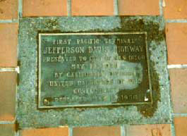
The first monument (on entering California from the east) most recently was placed at the Sand Hills Rest Area on I-8 Exit 155 soon after leaving Arizona. Its original location was at the Agricultural Inspection Station on the border, about 20 miles away. I suspect it has since been removed. The next, at Horton Plaza in downtown San Diego, is a 1956 brass plaque set into red tile pavement marking the "First Pacific Terminal" of the highway. A plaque was first placed there in July 1926, but objections raised by veterans of the Grand Army of the Republic caused it to be removed by the end of that year. 30 years later apparently no veterans were left to object and another monument was placed there. The latest placement was done during a 1985 rehabilitation of the plaza, but was again removed in 2017 during the nationwide furor over displaying Confederate flags and the like. The "Pacific Milestone" marker for the Robert E. Lee Highway, the self-same stretch of road, sits nearby.It seems that the named highway route as it crossed southern Arizona and California heading to San Diego was known as (take your pick) the Robert E. Lee Highway, the Dixie Overland Highway, the Bankhead Highway (for John Hollis Bankhead, an Alabama politician and Confederate war hero), the Old Spanish Trail and/or the Jefferson Davis Highway. After 1926 this stretch of road became part of non-controversial agenda-free US80.
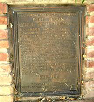
With the Pacific Ocean just a few blocks from the original terminus in San Diego, the revised and updated Jefferson Davis Highway route needed to take a sharp turn north to continue on. On reaching Los Angeles, the designated route followed what became US99 after the 1926 number assignments. The marker placed in 1942 on US99 in Lebec (north of LA on the "Ridge Route") was moved to Ft. Tejon State Park in 1956. This one commemorates the experimental "Camel Corps" created by Davis when he was Secretary of War before the Civil War (1953-1957) as well as dubbing him "Father of National Highways."
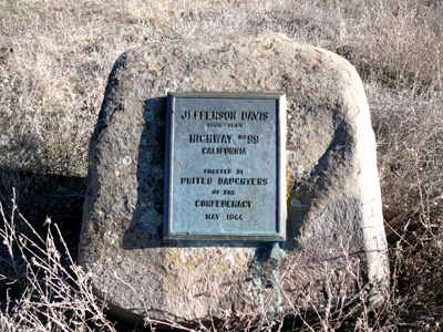
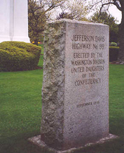
A monument in Bakersfield was moved off of Highway 99 and to the Kern County Museum grounds some time after 1968. It can be found on the edge of an obscure employee parking lot on the museum grounds. Lastly in California, a monument (brass plaque on granite boulder) placed on US99 just below the California/Oregon border in 1944 was relocated around 1970 during the construction of I-5. Until a few years ago it sat seldom-noticed on the edge of the southbound offramp of I-5 Exit 796. Thirty-some years later the "Clampers" (E Clampus Vitus group) moved it down the highway to Hornbrook, to join two other unrelated historic markers at the town entrance off I-5 Exit 789. In spring 2020, in the wake of the the national Black Lives Matter protests and increasing dismay over all confederate monuments, the plaque mysteriously disappeared.
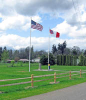
No markers were placed in Oregon, leaving quite a gap in the ōcontinuousö highway. But in the state of Washington the UDC in 1939 erected twin stone monuments on US99 at either end of the state with the blessing of state highway officials (although without official legislative recognition). Several decades later the southern marker in Vancouver was removed from its spot at the state line and, after some animated public hearings was erected on the grounds of the former Carnegie Library, now the Clark County Historical Museum. The presence of the monument was ever controversial and it was removed from there in 2006. However, the marker eventually was given a new permanent home, a small park (Jefferson Davis Park) a few miles north in Ridgefield, Washington, right on the edge of the interstate on a short remnant stretch of old 99. A group called the Sons of Confederate Vererans spearheaded the move.
At the Canadian border crossing in Blaine, Washington the JDH marker was the first honorific monument of any kind to be seen on entering the United States. It was dedicated in a 1941 ceremony attended by many US and Canadian officials. It was placed (ironically?) within feet of the imposing Peach Arch and for sixty years after the dedication seems to have been mostly unnoticed. Until 2002, when Washingston State Representative Dunshee from Snohomish discovered the monument and was apalled. Dunshee proposed renaming the highway the William P. Stewart Memorial Highway after a Washington state African-American who fought for the Union in the Civil War, and threatened to ōrip outö the monument himself. The road was not renamed (in fact, it never had been officially named in the first place) but the Blaine monument was removed.In 2008 it was transported south to the Ridgefield park and erected near to its "twin."
Those of us with no southern ties or sympathies could find a road (or anything at all) honoring the President of the Confederacy hard to swallow, and calling him Father of National Highways to be quite a stretch. Yet Davis did have at least a tenuous connection to roads in the west. Before the Civil War Davis had a long career as a congressman, senator, Secretary of War and presidential advisor. A believer in Manifest Destiny, he exhibited a strong interest in ōopening upö the west, which included securing funding for and directing surveys of wagon roads and railroads. The Camel Corps mentioned above is an amusing sidestory. Freight-carrying camels brought over from Egypt and Turkey tread a path from Texas to California in an army experiment that had mixed results and ended with the Civil War. The marker in Lebec marks the terminus of the "camel trail" as being there, "on part of the Jefferson Davis Highway."
In a way, the Jefferson Davis Highway was always more of a concept than an actual road. Or, as one scholar has observed, more of "a collection of markers located where UDC members were able to get permission to place them" rather than a coherent route. The routing doesnÆt seem to have been firmly established, some southern states officially recognized the highway while other states and the federal government did not. Nevertheless, monuments went up, although to little effect out west where ōUS Highway 99ö was firmly entrenched by 1930. Yet to this day the UDC still promotes the highway and keeps tabs on their markers. However, it would seem that ōThe Jefferson Davis Highwayö as an entity never quite jelled, most especially on the west coast. The markers and phantom highway have essentially served (at best) as a memorial to Davis and/or (at worst), as some have suggested, a veiled attempt to promote a Confederate agenda.
A few of the sources used in this article:
"Jefferson Davis Memorial Highway" by Richard F. Weingroff, accessed at the Federal Highway Administration website.
 HOME
HOME