
Questions?
Email us at: JandK@LivingGoldPress.com
 HOME
HOME
| |
Email us at: JandK@LivingGoldPress.com
|
|
Five (Roadside) Faves in |
Road Notes, Society for Commercial Archeology News Vol. 18 No. 2 Summer 2010. More about Society for Commercial Archeology |
All of these chosen Southern Oregon "faves" are along the old Pacific Highway/US99 route, the north-south highway that ran from Canada to Mexico. I had trouble narrowing it down to just five. I could have named five (or more)bridges, five (or more) vintage signs, five (or more) buildings, but I decided to go for a variety of roadside delights for your vicarious pleasure. |
 |
|
Grants Pass BeaconThe Beacon Cafe was built in 1929 as a gas station. It was one in the chain of Richfield Beacon gas stations strung along US Highway 101 in California and US99 in California, Oregon and Washington. Only a few still stand. They were built on the edge of or even far outside of towns, often near small airports. Richfield was pitching aviation as well as automobile fuel; the lighted 125' tall tower in front of each station pointed the way to the nearest airport. Remember, this was prior to radio beacons. Pilots navigated visually at that time, often guided by roads or train tracks and lights, and Richfield strove to create a "Lane of Light". Their beacons became part of the government airway beacon system. The stations were designed to be deluxe, stylish improvements on the usual utilitarian box-style gas station structure. It was expected that motels and other services would be built around these outlying establishments, plans that the Depression doomed. Most of the stations were quickly leased or sold out of the company, although some still served as gas stations for many years. The Grants Pass Beacon was built in the steeped-roof style of all the northern stations. In California, excepting the one farthest north in Mt. Shasta city (also still standing), the stations were built, appropriately, in a red tile roofed Spanish style. | |
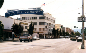 |
The "Climate Sign", Grants Pass There was a time when every little town that could possibly afford to strung a welcome sign or a slogan sign across their main street, which was usually also the through highway. Or even better, they built a welcome arch at the town entrance. Very few of either are left, but Grants Pass still proudly displays the "It's the Climate" sign that dates from 1920. Well, technically it's a replica, in a typical case of not appreciating what you have until it's gone, and losing things that should be kept track of. Early 20th century town boosters stressed the suitability of the local climate for orchards and vineyards. One of them forked out $471 for the lighted "climate sign" that stayed for twenty years. After property owners abruptly forced its removal in 1941, the sign was erected on city property at the entrance to Riverside Park. But, by then unloved and probably in a state of disrepair, it disappeared again in 1958, location unknown. By 1976, the loss was felt, and $5000 was raised with little trouble. A nearly exact replica of the sign was commissioned as a Bicentennial project. It was hung back in the original downtown location, where it still hangs today, the town's most identifiable landmark. |
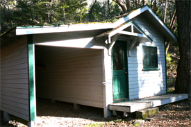 |
Lithia Auto Camp CabinBefore Ashland, Oregon became known for its Shakespeare Festival people came for the waters. They first arrived by train and then by car to bathe in a number of healing spas and to drink the Lithia Water that still flows out of public drinking fountains. (Warning: take a very small swallow, it's strong-tasting stuff.) Ashland opened a free 92-acre public auto camp ("The Finest on the Pacific Highway") in 1915 in the city park next to the Chautauqua grounds to attract affluent motoring tourists. Remember, at that time only the better off had cars, and many of them were motoring down to San Francisco to take in the Panama Pacific Exposition world's fair. In 1922 a 50 cent fee was imposed. A store and cabins were added to the campground in 1926. The camp advertised three kinds of mineral water, playgrounds, wading pools, kitchenettes, electric lights, a "comfort station of the most modern type", and laundry service. Amazingly, the last of the cabins with its attached carport has been preserved, and the campground "community house" now houses Ashland's Parks Department. Lithia Park must have been a wonderful place for the auto camper of yore, as it is to this day. Campers must have been reluctant to drive away from the creekside setting within walking distance of town amenities. When the campground closed in 1959, the clientele had most definitely changed. |
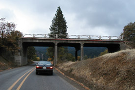 |
Steinman OvercrossingOregon is a land of mountains and rivers, so historic bridges are an expected roadside treat. A number of concrete arch bridges crossing the Rogue and Umpqua Rivers are thankfully still in place, but Steinman Overcrossing located just north of the California border is an old favorite. By old, I mean closing in on 100 years. It is sometimes referred to as "the over and under" as this is the only bridge in Oregon where the road goes both over and under the structure. The track of the Siskiyou Line also passes beneath it, as seen in the real photo postcard view from Eastman Studios. The 78-foot reinforced concrete deck girder was built in 1914 on what was the Pacific Highway. Earlier, an emigrant trail and then a toll wagon road took the same path. In 1926 the Pacific Highway became US99. By 1940 US99 had been realigned to the west on a much gentler grade, leaving this steep, windy, several-miles-long stretch of original highway over the Siskiyou Mountains that separate Oregon and California gloriously intact. |