
Questions?
Email us at: JandK@LivingGoldPress.com
 HOME
HOME

| |
Email us at: JandK@LivingGoldPress.com
|
|
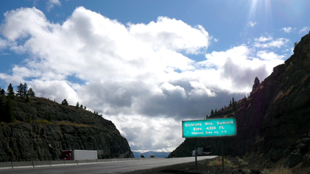
Highpoint of Highway 99, |
|
| Siskiyou Pass currently tops out at 4310'. | |
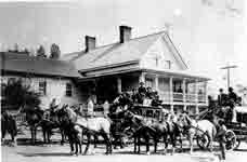
Barron's Mountain House, a stage stop on the Siskiyou Trail. |
 |
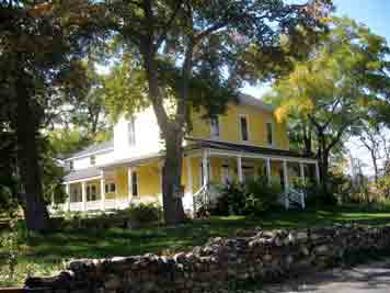
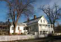
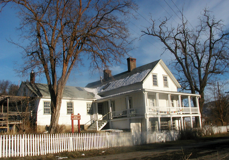
| Coles Station was the last stage stop on the California side of the Siskiyou crossing. It still stands (see photo below).
GO TO a larger photo |
 GO TO a larger photo of Cole's now. |
|
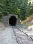
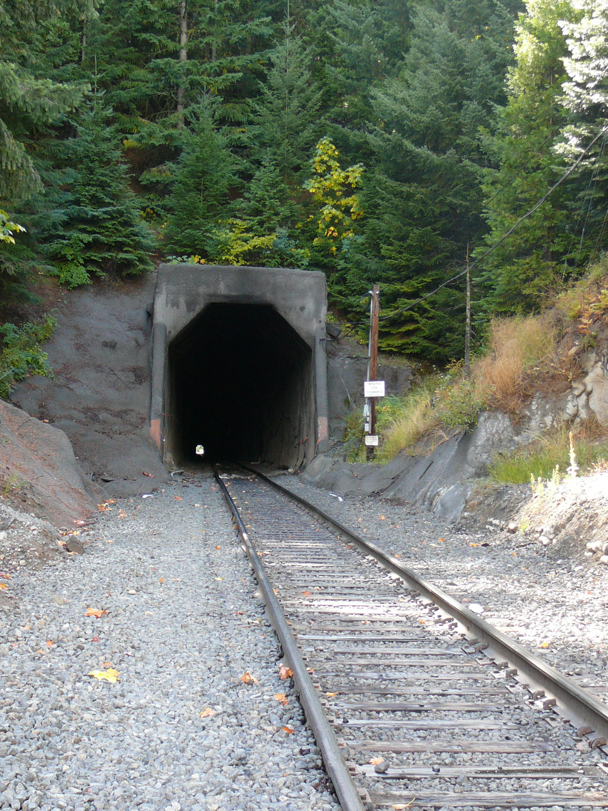
| Tunnel 13 has cut through Siskiyou Pass since 1887 and is 3108' long. GO TO a larger photo |
Part Two |
|
Siskiyou Mountain Wagon RoadHeady with dreams of striking it rich, excited Oregonians poured over the Siskiyou Pass en route to California’s Mother Lode soon after the 1848 gold discovery. Then in 1851 gold was discovered in the Siskiyou region, and the migration reversed direction. The mountain crossing sat at the center of the new northern mining area, a rough and difficult passage over the pioneer Siskiyou Trail usually made on foot or horseback, occasionally (but not often enough!) by wagon in the summer months. Soon enough, local entrepreneurs stepped in to fill the demand for a real road brought on by the mid-century population “explosion”. In the 19th century the government didn’t provide money or workers to build roads; they only granted permission for the work to be done. Toll roads frequently appeared in places where there was no alternate route and the terrain rugged, where the investments of money and labor were such that a toll was justified. The Oregon Territorial government was petitioned for permission to build such a road over the Siskiyous. Permission was granted in 1857 two years before Oregon statehood, and the first toll was collected in August, 1859. The Siskiyou Mountain Wagon Road was the first “engineered” road over the mountain crest that separates California and Oregon. Surveys were done to determine a routing that varied slightly from the Siskiyou Trail used by immigrants and miners. A little excavation was done, a few culverts put in, a toll station built. The toll station building known as Dollarhide’s located a mile and a half north of the pass later burned in a forest fire. Still standing are two stage stops that that originated in the Trail era and later provided rest and meals for Toll Road travelers. Cole’s Station just over the California line is now a private residence, and Barron’s Mountain House on the Oregon side is a bed and breakfast that serves Ashland, Oregon. The wagon road had to be maintained and the snow packed to keep the road open in winter. It was all quite a struggle. Profits were small. At $1.50 per loaded wagon, and 5¢ for a horse, cow or pig, there wasn’t much potential for getting rich on the venture. There would have been little profit at all if not for the two daily stages which paid $40-$80 a month for passage. In December 1866 collected tolls came to $107, of which $80 was paid by the California Stage Co. The stages ran from Sacramento, California to Portland, Oregon, and what made them profitable was a lucrative contract to carry the US Mail. They ran on a tight schedule. The contract required that the mail be carried from point to point in seven days in summer, twelve days in winter. This 710-mile route was the second longest stage run in the US. Modern visions of stagecoach travel may be romantic, but this mountain crossing couldn’t have been a comfortable ride, squeezed in like sardines, no one bathing for several days, bumping along rough roads and over rickety bridges in the dark of night knee-to-knee with strangers. Frequent accidents added to the excitement; wheels flying off, stages tipping over, horses running wild. But whatever its flavor, this era too came to an end. A railroad over the mountains was the next much-anticipated mode of modern travel. Still, the Siskiyou Wagon Road hung on as a private enterprise after the trains started running until replaced by the government-funded Pacific Highway in 1915. |
Trains Make the GradeOne might say that a whiff of train engine smoke was already in the air before the first stagecoach barreled down the Siskiyou Mountain Wagon Road. Four years earlier in 1855 the Williamson/Abbott Railroad Survey passed through the area and over the summit. It was the final of twelve such survey parties deployed throughout the west in search of possible routes to tie into the transcontinental railroad still being constructed at that time. As in the earlier Wilkes Expedition (see Part One), the Railroad Survey crews included scientists and artists who carefully recorded so much valuable information that the published reports have been called “the first Environmental Impact Statements”. It would be three decades before any track was laid however, and the railroad companies themselves did the more detailed survey work. It seems to have been difficult to sustain interest in and financing for the steep, difficult crossing and to decide on the best routing. Progress was slow. Although work had begun, from August 1884 through May 1887 no grading, blasting, trestle building or track laying was done in the Siskiyous. Trains from the south stopped at Coles, from the north at Ashland, the two railheads connected by the bumpy old stage road for over three more years. Eventually the Central Pacific Rail Road of “Big Four” fame picked up the pieces of the failed Oregon and California Railroad and resumed construction. Much of the previous company’s proposed route was ditched in favor of one shorter and cheaper to build but with a steeper grade. Partially constructed Buck Rock Tunnel was abandoned to become a popular 21st century destination for hiking railroad buffs. The extended Dollarhide family was most enterprising. As owners of the Siskiyou Mountain Wagon Road since 1875 they worried about how the new rail line over the Siskiyous would affect the number of travelers passing through their tollgate. Yet at the same time they supplied the slow-moving railroad builders of the mid-1880s with lumber for ties and trestles cut off of their land, even as they fumed over the mess being made of their toll road in places where the road and the new tracks crossed each other, a total of seven times. As the rail line inched its way both north and south towards the eventual joining, the stage line grew progressively shorter until December 17, 1887, the day a Golden Spike was driven in Ashland, Oregon, the first real town on the north side of the mountains. When the last stagecoach rolled through the next day the driver wielding the long whip was Dan Cawley, a well-known 30-year veteran driver who had also driven the very first stage to traverse the road in 1857. Easy traveling and scenic train excursions instantly replaced the rough-and-tumble stagecoach journey, and it was only a two hour ride over the mountains.. Travelers now flocked to the comfortable Colestine Mineral Springs Resort in the mountains right beside the tracks and crossed Siskiyou Summit inside the 3108’ long Tunnel 13. Perhaps the unlucky number foretold that this tunnel would be the site of the purported last train robbery in the US in 1923. The robber’s bungled attempt at robbing the mail car left four people dead and no cash in their hands, but they eluded capture for several years. More recently, in 2003 the tunnel was closed for over a year after a fire (surmised to have been started by homeless campers) damaged the supporting timbers. Alas, passengers haven’t traveled the Siskiyou Line since 1952.
|